Stewart Island Circuit | ebook
Rakiura National Park, Stewart Island. It’s a beauty.
Where else can you wander around a remarkably scenic coastline untroubled by too many people, actually often no one else, no cars, no roads, no powerlines, no fences, no farm stock, no planes flying overhead, no screen interfaces, no internet or cell phone reception, often, basically no civilisation in toto except what you can carry on your back, for many days, even a week or two? A track with acceptable if austere accommodation provided at a moderate cost, well, at least there’s a roof overhead and a comfy plastic coated mattress to drop horizontally onto at night. A terrain with no high mountain passes, or fast flowing mighty river torrents to traverse and even the legendary endless river of mud seems not so troubling when in amongst it, for the most part.
The North-west and Southern Circuit combined tracks end up being quite the challenge, primarily because of the distance, 181 km by my reckoning, together with the need to trudge burdened, at least initially, with a food load for the complete journey, a couple of weeks perhaps, that weather, you get plenty of it, and, for some anyway, the perceived isolation.
Let’s face it, there aren’t many places on Earth, like standing on Doughboy Hill, ie, a bump on the ridge between Doughboy and the Rakeahua valley, where you can look south over to the vast and empty of humanity Tin Range, and realise you might be the last person between civilisation and Antarctica.
Yeah, this is truly an expedition to the perimeter of the inhabited world.
Download Stewart Island Big Circuit
from the Amazon Kindle Store. Or click on the image.

Length: 8,100 words — equivalent to a 31 page paperback
File size: 2810 KB
File format: .mobi — read in the Kindle app
Cost: $3.99

Here’s an extract:
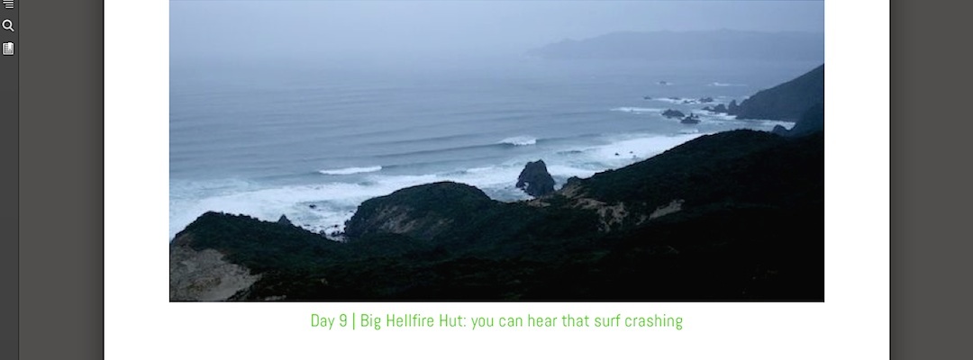
Day 11 | Doughboy Bay Hut: the best, and for a short while worst, of a day
Not so many do the Southern Circuit and if they stay at Doughboy there’s a good chance air transportation is involved.
It’s a fair day’s hike from the Mason Bay Hut but it starts as easy as can be, a 5 km stroll down the beach, just less than completely firm sand, a cool morning, say 5º C inside the hut, but little wind, and, another day of surprisingly cloudless sky. The vest has to come off.
The track up Adams Hill is what you hoped the North-west Circuit could be, evenly graded, mostly, through rimu, kamahi and miro forest with a fair sprinkling of rata and totara, easy enough to plod on or take a break on a mossy pozzy, to, err, listen to the birds in this direct sunlight. The track itself is not hacked up, too much, by marching feet.
At the top there’s a huge payoff for effort expended, views all the way back to Codfish Island/Whenua Hou, strange to look back to those distant hills near Big Hellfire Hut, it was like only 30 hours ago I was sitting up there contemplating this point in hazy indistinctness, then around to the Ernest Islands that protect the southern section of Mason Bay, over to the trackless Tin Range to the south and around to the western slopes of Mt Rakeahua.
You can’t see Doughboy Bay itself but the hills to the south are clear enough. Above 300m the flora stops being defined as forest and becomes scrubby, towards the top, 400m, it’s more heathland, chest high shrubbery with areas of moss and low ground cover between the larger vegetation.
Those closely shorn areas are, err, boggy, maybe even bottomless, it’s hard to tell with the dark brown porridge, and the task becomes one of finding your way across those gaps lacking vegetation at all. You can jump near the edge, I have a large stride which comes in useful, the entire landscape shudders and oscillates on touchdown.
Over the other side, the southern slopes, the first 40% of the descent becomes a test both physically and mentally. Swinging on the shrubbery, standing on slithery, slippery tree roots and not always successfully avoiding the deep morass that for some reason is here labelled “track”. It’s a very shady south side of the hill, the route plunges straight down the slope but for some reason the thin porridge of a liquid is retained on said slope. Eventually there’s a sidle around to a ridge, and, voila, back on a beaut, if steepish track devoid of rotting vegetative soup.
And you pop out onto a long, lonely beach that has had its share of visitor over the years, Maori paddled down here on their way to the tiwi islands, looking for muttonbirds, 200 years ago sealers stayed in the cave but tonight it seems I’m the only Homo sapiens present.
Still no cloud in the sky, Paradise indeed.
