Wandering the Larapinta | ebook
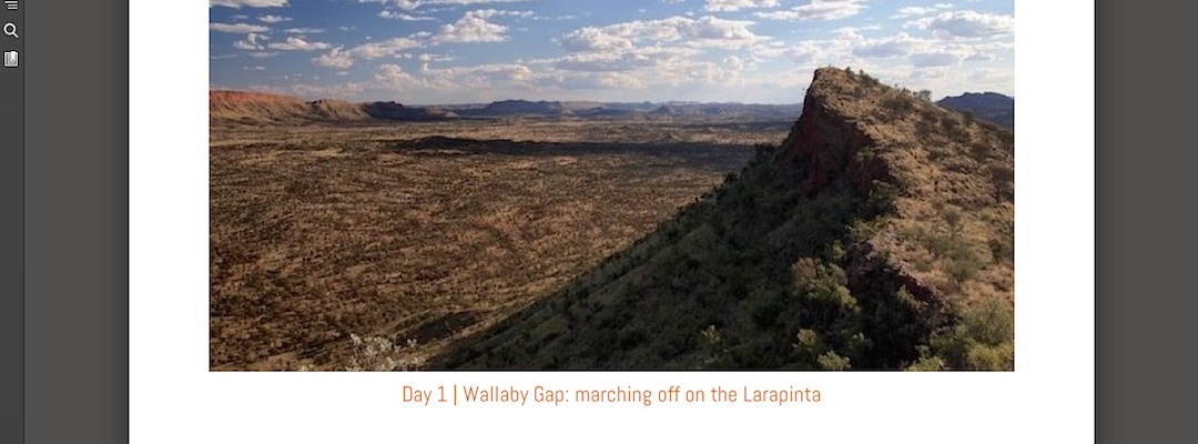
The Larapinta Trail is a 223 km wander through the main ranges of the West Macdonnell National Park, just west of Alice Springs in Central Australia. You can take anywhere between 15 to 20 days for what’s called the End to End, the time depending on your enthusiasm for trudging. The best time for the traverse is between May and August, inclusive, but certainly not in summer when in addition to the heat, ie, 40º C+, there is a significant disincentive: bushfires. Water is the major determinant for any itinerary, there are tanks at all but one of the major campsites, unless you want to carry plenty of water it’s probably sensible to camp adjacent to a water tank.
So, I’m quite the travel guide.
There’s no excuse not to go, I’ve got all the gear, with one notable exception, a pack, it’s fantastically scenic, and was briefly contemplated, once upon a time, ten years ago, but I found some other way to occupy my time. I’ll see how much I can crack out in two weeks which is probably about as much food as I can be bothered to carry, considering you also have to lug a tent and sleeping gear.
This ebook, however, has personal observations from a 13 day walk that managed just 132 of those kilometres, albeit the more scenic parts, and bearing in mind I’d previously acquainted myself the most spectacular, and final, section a couple of times, climbing Mt Sonder.
Download Wandering the Larapinta from the Amazon Kindle Store. Or click on the image.

Length: 7,700 words — equivalent to a 35 page paperback
File Size: 1776 KB
File format: .mobi — read in the Kindle app
Cost: $3.99

Here’s an extract:
Mt Sonder | time for a walk up a hill
Happy?
You betcha. Today I’m verging on ecstatic. A lovely, calm morning that turns into the most pleasant background for a day in weeks, there’s even plenty of blue sky.
I wander up Mt Sonder, known by its Aboriginal name as Rwetyepme, the fourth highest hillock in the Northern Territory, 1380 m high, well, let’s be truthful, it ain’t exactly the Himalayas, two hour walk to the top, less coming down, in time not distance. Actually the sign at the bottom says allow eight hours, that’s a stretch, intended to put off all but the most enthusiastic climbers, sad there isn’t more encouragement for people who might be unaccustomed to such exercise.
For me, no problem, I guess my leg muscles are well accustomed to a daily bout of exercise.
I’m happy as climbing that hill, you get most of the steep stuff over in the first section then only having the odd steepish climb, a healthy 8km each way.
But at the top, not going to call it a summit, is one of the great views of the Northern Territory, in fact Australia, it’s almost 360°, you can see Haasts Bluff, 64 km to the west, back to Gosse Bluff, 37 km and the full West Mac range, from Mt Zeil, the highest pinnacle in the Northern Territory, 1531 m, 27 km away, all the way around to Mt Giles, the third highest, only just pipping the lump I’m perched on.
There’s the much smaller range, not sure of the name there, not so far to the south. There’s no substantial creeks flowing down the wide valley. Instead, for some crazy reason, like some junior town planner, without any clue, drew a doodle on the map of the region, the creek coming out of Redbank Gorge, Davenport Creek, joins up with the one in Ormiston Gorge to form the Finke River, the oldest watercourse in the world, which flows along that doodle, well sometimes, on occasions for the last 100 million years, through a couple of mountain ranges, well, gashes through hills anyway, Glen Helen Gorge, off to its extinction in the Simpson Desert 700 km away.
That’s whenever it flows, the water component of the Finke is not exactly a permanent phenomenon, mostly it’s a sandy creek bed, but when the rare humungous downpour arrives from the Tropics, usually summer, the catchment being vast and the slope not insignificant, the Finke rages 10m, 15 m deep through the bottleneck of the gorges, until, well, it always putters out in the Simpson.
There’s a bit of haze, but the colours are only slightly muted, reddish, mauve, violet, basically either end of the spectrum will do. The humps and curves around Mt Giles are audacious, the shapes immediately south look so precise, as if they were done with a comb.
When I came up here first time around a couple of years ago there was a cast of thousands, well, today I counted 78 names for that day inscribed in the book at the summit, most had been travelling in two big buses on a school trip from Darwin, cheerily singing their Christian songs and having the fully exuberant day out that the typical bunch of extravert teenagers unleashed in the wilds can achieve.
Today I had the day, the hill, that view, to myself.
Like many intense landscape experiences, sunrise over Lake Eyre, sunset over the Tanami, huddled in Cathedral Gorge in Purnululu, or watching the busting surf in the Leeuwin Naturaliste National Park, the mind can scarcely take this vista in, photography a poor substitute.
At least you can think, I am here, I am thrilled and I am living this incredible life.
Standing on the cliff at the top looking out to forever and ever. I knew I had the perfect day.
